Action Alert

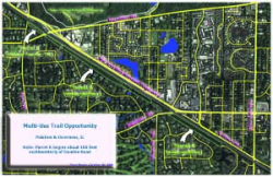
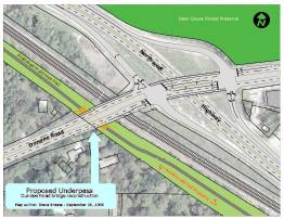
Trail Opportunity: Northwestern Greenway

The webmaster of the Greenway Planning Database, Steve Breese, has proposed a new multi-use trail along a vacant strip of property along the northern boundary of Inverness.  Efforts to secure a pedestrian underpass under Dundee Road during the current bridge recontruction project have been unsuccessful. (see Timeline below) 

Greenway Corridor

The trail would be built on a 1.75 mile strip of land located immediately south and parallel to the Union Pacific Railroad between Quentin and Dundee Roads.  Most of this corridor is preserved as a trail easement along the rear lots of single family homes.

click here to download Corridor Planning Map

DOWNLOAD CORRIDOR MAP - FULL AERIAL 12.4 Mb
DOWNLOAD CORRIDOR MAP - AERIAL ONLY WITHIN CORRIDOR 7 Mb


DOWNLOAD UNDERPASS CONCEPT MAP 2 Mb

Trail Easement

Arthur T. McIntosh's vision for Inverness included bridal paths linking all areas in the Village.   That's why he included a trail easement along the entire northern border of his Baldwin Hills subdivision "for the use and benefit of the residents of Inverness".

Download Baldwin Hills Subdivision
DOWNLOAD BALDWIN HILLS SUBDIVISION (930 Kb)

Pedestrian Underpass

Reconstruction of the Dundee Road bridge over Union Pacific Railroad and Northwest Highway is currently taking place.  Efforts to secure a pedestrian underpass have come to late.  This $13.4 million bridge project includes no bicycle or pedestrian accommodations.

Download Engineering Plans
DOWNLOAD IDOT ENGINEERING PLANS (13 Mb)


Timeline

This timeline lists all action taken in the development of this trail.


Existing Conditions

IDOT itself has rated both intersecting roads as "NOT RECOMENDED FOR BICYCLING" on their Official Bikeway Map (3.4 Mb).  No sidewalks exist on either roadway.

Description of Bridge Project

The proposed typical section of the bridge carrying Dundee Road over the UP Railroad and U.S. Route 14 is to have two 12' lanes and an 8' shoulder in each direction.

Shortcomings of this design


Examples of what I was proposing:


Which Trail?

A trail along and parallel to the south side of Union Pacific right-of-way is shown on plans produced by 5 municipal, 2 regional, and 1 county government agencies.  These are listed here:

        = trail proposed at subject location

Notes regarding these plans:


Trail Name

According to the 1997 NIPC Greenways and Trails Plan, this trail is referred to as \"Union Pacific Corridor" in McHenry County.  The trail connection between Deer Grove Forest Preseve and Crabtree is known as "Crabtree to Deer Grove Corridor".  Forest Preserve District of Cook County proposes a trail called C&NW RR Trail in their Land Acquisition Plan.

I have given this trail a working name of "Northwestern Corridor".


Key Person Contact Info

Note: E-mail address for most contacts can be requested via Contact Web Form

Get involved!

If we don't act now, IDOT will maintain another barrier to safe and enjoyable recreational and commuter cyling.  When barriers are not removed when opportununities arise, local governments resort to building sidepaths along uninviting highways at the expense of potentially popular greenway trails built far removed from automobile traffic.  


I invite you to be a part of something that will benefit our communities for an eternity.  Please submit a message via the Contact Page if you wold like to receive updates and notification of project meetings.


»»»»»
Greenway Trails
» » »Existing
» » »Project
» » »Potential
Greenway Maps
» » »by Agency
» » »by Scope
Community Systems
» » »Active
» » »Typical
» » »Sedentary
» » »Dead-end
Grade Separations
» » »Existing
» » »Needed
Trail Development
» » »News

» » »Events
Greenway Advocacy Materials
Bicycle Underpass/Overpass Gallery
About Greenway Planning Database
About Steve Breese
PalatineRoad.com
Contact Steve Breese
Greenway Links

ArlingtonTrotters.com
Fast Track Racing Team

COGO
Technical Corner